 |
| Saturday, May 14, 2011 -- Photo Courtesy Rusty Johnson of Lake Village, Ark. |
Updated 5/19/2011 @ 12:20 am 5/16/2011 @ 10:50 am 5/14/2011 @ 11:25 am; 5/10/2011 @ 12:30 pm and @ 8:20 pm
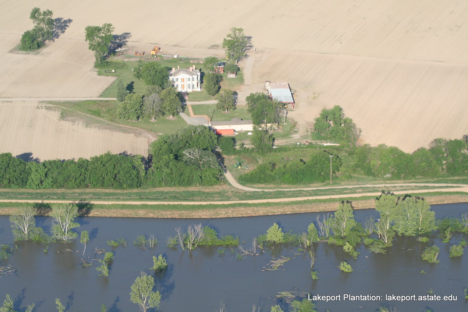
Lakeport is on dry land, but over the levee, just 800 feet away, the flood waters are nearing their crest.
MS Levee Board News 5-20-2011
The MS River has crested at Arkansas City and Greenville and is cresting at Vicksburg!
UPDATE – May 18, 2011
CURRENT GAGE READINGS
Arkansas City 52.7’
Greenville 64.0’
Vicksburg 57.1’
MS RIVER FORECAST
Arkansas City Crested May 16th at 53.1’
Greenville Crested May 16th at 64.2’
Vicksburg Cresting at 57.1’
This highwater exceeded the 1973 highwater levels by 6’.
This highwater put us 3.2’ above the 100-year flood on the MS River.
The 100-year flood on the MS River is 61’ at Greenville and 54’ at Vicksburg.
MS Levee Board News 5-15-2011
The MS River is cresting at Arkansas City!
UPDATE – May 16, 2011
CURRENT GAGE READINGS
Arkansas City 53.1’
Greenville 64.2’
Vicksburg 56.5’
MS RIVER FORECAST
They lowered the Greenville crest by 6” to 64.5’ on May 17th:
Arkansas City 53.1’ cresting
Greenville 64.5’ crest on May 17th
Vicksburg 57.5’ crest on May 19th
This forecast will exceed the 1973 highwater levels by 6’.
This forecast will put us 3.5’ above the 100-year flood on the MS River.
The 100-year flood on the MS River is 61’ at Greenville and 54’ at Vicksburg.
The Corps of Engineers, at a meeting at the Chicot County Courthouse in Lake Village on 5/9/11 and 5/10/11 (the ones I attended), assured citizens that the levees are holding up and they are designed to withstand this historic flood. These informational meetings will be held every day at the Chicot County Courthouse at 4 pm until further notice.
A few other points the Corps made:
- Levee system is in good shape.
- Fields are dry; a few inches of rain will not be a problem.
- The rise
hasslowedthis week; has crested, but will be a slow draw down. - We will have highwater into June. Our northern neighbors are holding a lot of water in their reservoirs that they will eventually have to release.
- the slow drop in floodwaters prevents the levees from sloughing
- There is some seepage along levees, but this is normal and not a concern.
- An older levee near Eudora was topped last week by the floodwaters; this levee is not part of the mainline levees.
- No water is or can be pumped into Lake Chicot. The pumping station at Lake Chicot is NOT designed to pump water into the lake--just out of it.
- Levees perpendicular to each other (directly across the river) have the same elevation.
- Sand boils are being monitored; they know where they are historically and none are considered a threat at this time.
- boils that are moving clear water are not a threat. boils that are moving material/dirt/sand are.
- it takes a lot of movement of material to consider them a threat.
- Watch for wildlife that have been displaced from their habitat by the flood.
- Gov. Beebe has activated the National Guard to help watch the levees in Desha and Chicot counties.
- approximately
3070 Guardsmen will be in the counties. - Good internet resources:
- Media reports in Chicot County
- KATV -- Floodwaters Rising in southeast Arkansas, Mississippi (5/15/2011)
- KATV -- River cresting Sunday [not sure if that day is accurate] in Desha, Chicot Counties (5/15/2011)
- Huffington Post (in Greenville, MS) -- At Epicenter of Past River Flood, A Town On Edge (5/14/2011)
- KATV --Chicot County Almost Out of The Water, Levee Holding (5/13/2011)
- Delta Farm Press -- Anxiety rises with river levels on Mississippi (5/9/2011)
- Southwest Times Record (Fort Smith) -- Members Of 188th Assist With Flood Relief (5/14/2011)
- THV -- Arkansas National Guard heads to Chicot County for flood preps (5/13/2011)
- The levees are fine.
And while you are here: Please vote for the Lakeport Plantation and 9 of your other favorite Arkansas places in the Department of Parks & Tourism's Favorite Places in Arkansas Poll. Lakeport is listed under "Attractions."
http://www.arkansas.com/175
If you compare the photos from May 4, 10 and 16, you can see the water has continued to inch up along the levee. (Tip pause the slideshow and look for comparable photos).
If you compare the photos from May 4, 10 and 16, you can see the water has continued to inch up along the levee. (Tip pause the slideshow and look for comparable photos).
In the Spring of 2008 the Mississippi River also rose and neared the top of the levee. The 2011 flood waters are expected to be 7.1 feet hight than 2008 (see Press Release below).
 |
| April 5, 2008 -- Lakeport can be seen to the Right. |
 |
| Levee reinforcements at Lakeport, April 1927 -- House in background -- Photo is Courtesy Library of Congress. |
Press Release from Chicot County Judge Mack Ball
May 4, 2011
Chicot County Judge Mack Ball reports that a flood warning for the Mississippi River remains in effect for Chicot County. The flood stage is 48.0 feet, with moderate flooding occurring and major flooding predicted. At 4:00 P.M. Monday, the river stage was 53.2 feet. The river will continue to rise to near 64.5 feet by Sunday, May 15th, exceeding the flood of 2008 by 7.1 feet.
The County Judge met with the Eudora Mayor William Stanton and Lake Village Mayor JoAnne Bush in his office Monday afternoon to brief the Mayors of rising waters from the Mississippi River. Also in attendance was Mike Morgan, Chicot County Emergency Management, the Tony Booker, Chicot County Sheriff’s office, David Gillison of the Southeast Arkansas Levee Board and Sammy Angel with the Lake Village Fire Department.
Judge Ball issued a flood disaster request to the Arkansas Department of Emergency Management on April 27, 2011 in order to obtain necessary supplies to prevent a breach in the Mississippi River Levee System. Barricades have been placed at all entrances to the levee system and driving on the levee is strictly prohibited and will be enforced. Sandbags are being filled by prisoners at the Delta Regional Detention Center in Dermott to be used at two sand boil sites in Chicot County. Authorities are constantly monitoring these two particular sites, but citizens are encourage to contact the Judge’s Office with any information concerning other suspected boils.
The U.S. Army Corp of Engineers has personnel in place to monitor the levee system and all known historical sand boils in Chicot County. Also, the Southeast Arkansas Levee Board is constantly monitoring for sand boils and river seepage caused by the high water.
As of May 2, 2011, no vehicles will be permitted to travel on the levee. The Chicot County Sheriff’s Department, Arkansas Game and Fish, Arkansas Department of Emergency Management and the National Guard will be authorized to issue tickets accordingly. This “zero tolerance” policy is in place to protect both the citizens and property in Chicot County. It is each resident’s responsibility to follow the laws and instructions from the Southeast Arkansas Levee Board, Arkansas Department of Emergency Management, National Guard, U.S. Corp of Engineers, Chicot County Sheriff’s Office and the Chicot County Judge’s office.
All major decisions by the Corp of Engineers or any other state or federal agency will be reported to the Arkansas Department of Emergency Management and the Chicot County Judge. The County Judge will notify the Mayors of each city in Chicot County. The steps will then be in place to inform you as citizens.
If a breach of the levee does occur, officials have developed a system of getting the word to you as a citizen by utilizing fire departments, law enforcement and the Arkansas National Guard. The authorities are simply asking for you to use all precautions and report any unusual developments.
In the event conditions warrant an evacuation all available personnel will notify the citizens of Chicot County. It is at this point that, EVACUATION WILL BE MANDANTORY and your cooperation will be necessary in order to protect both life and property in Chicot County.
At this time only precautionary measures have been issued from each of these entities. Please know that all authorities are working together for your protection. All state and national agencies are on alert for any additional changes in the present conditions of the Mississippi River.
Interesting description of sand boils in Chicot County in 1973:
ReplyDeleteWilliams, John Glynn, "Sand Boils: A Modern Analogue of Ancient Sand Volcanoes" Arkansas Academy of Science Journal v. 28, 1874.
http://libinfo.uark.edu/aas/issues/1974v28/v28a28.pdf
Praying for the personal and property safety of Lakeport and everyone involved!
ReplyDeleteArkansas Times post on I-40 closure in eastern Arkansas:
ReplyDeletehttp://www.arktimes.com/ArkansasBlog/archives/2011/05/04/flooding-woes-mount-i-40-blocked-in-e-ark